Old Croton Aqueduct Trail
- Brothers Welch
- May 6
- 11 min read
Updated: May 8
The Old Croton Aqueduct Trail, or OCA, is a 41-mile trail extending from the front steps of the New York Public Library’s main branch to the wall of the New Croton Dam in Croton-on-Hudson. It runs through numerous New York City Parks, including Central Park, Highbridge Park, and Van Cortlandt Park, before entering the 26.2 miles of the Old Croton Aqueduct State Historic Park through Westchester County. [1]
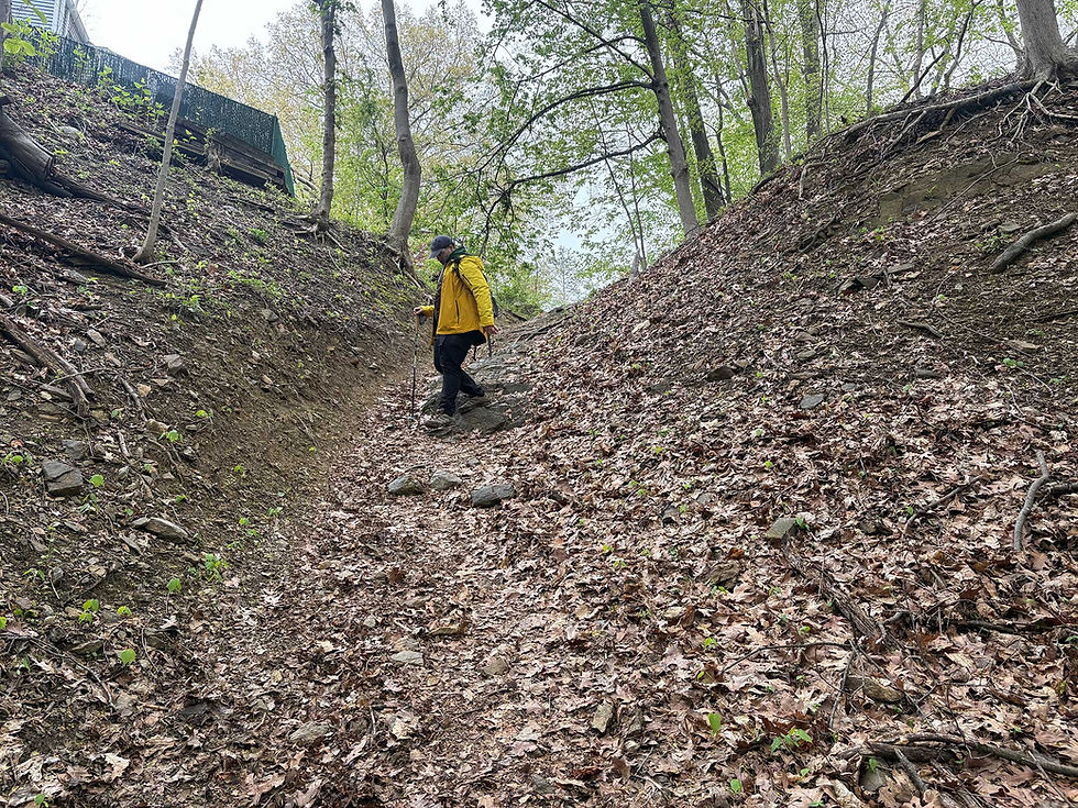
I hiked it a few Falls back with my friend Ranger Rick and was excited to pick it up again with Jon, "J-Dub", this time in the Spring.
J-Dub and I broke it up into a five-day hike over the course of a month. This is similar to how I hiked it before and would be my suggestion for anyone looking to trek the trail. The intriguing detours and easy on-offs from the city with subway and Metro-North stations make the OCA a good trail for anyone curious about local history, regional ecology, and the communities along the Hudson River.
Day 1: New York Public Library to Highbridge
We took the subway to Bryant Park and began our hike at the southern terminus of the Old Croton Aqueduct Trail, the steps of the New York Public Library. This was once the site of the Murray Hill Distributing Reservoir for the Aqueduct system. [2]

From here, we turned north onto Fifth Ave and weaved our way through early Spring tourists enjoying the window displays. We made a pit stop at Sant Ambroeus, paying Upper East Side prices for an admittedly very good cup of coffee. Caffeinated and hydrated, we made our way into Central Park.

The map showed the trail turning right before the Met on 80th, but this put us in the Met’s garage. To turn into the park itself, we used the “Miner’s Gate” between 80th and 79th. The trail gives you two options around the Great Lawn. We chose to walk the southern perimeter and get a view of Belvedere Castle and the Delacorte Theater, as well as use the public restrooms by the Delacorte. We took some time looking for the “Stone Wall Remnants” on this western side, but didn’t have any luck.

Making our way into the Upper West Side, we passed by old aqueduct infrastructure in and around Columbia, before steadily climbing the long, steep hill up to City College’s Campus. Once there, the rest of the walk was level enough over to Highbridge Park. Here we opted to take the route through the park, and the switch from concrete to trail tread felt very welcome.
We ended down on the Highbridge itself, enjoying the late afternoon over the Harlem River before heading back.

Day 2: Highbridge to Yonkers (South County Putnam Trail)
We started our day mid-morning on the Highbridge, walking from Manhattan into Harlem to complete the next NYC.

The trail crossed the Cross Bronx and passed by the Sedgwick Houses before continuing on down University Ave and the University Malls. We next picked up the Aqueduct Walk, a “shoestring park” [3] developed in the 1930s and 40s running between Kingsbridge Road and West Tremont Avenue. [4] This elevated path took us through playgrounds, backyards, and the busy outer rim of Fordham Plaza, then to the Kingsbridge Armory.


There are other interesting destinations and diversions as well such Poe Park with Poe Cottage, where he wrote “The Bells,” “Eureka,” and “Annabel Lee.” [5] We made our way past the Armory and toward the Jerome Park Reservoir where we peaked up Reservoir Ave and checked out a view of the 94-acre body of water. The OCA follows the trail down the eastern edge of the reservoir into Van Cortlandt Park.

The Aqueduct Trail in Van Cortlandt enters on a larger Moshulu-Pelham Greenway section of the Bronx Greenway [6] and then wraps around the bike path to a bridge along the interstate before connecting in the Park’s northeast forest and merging briefly with the John Muir trail. The northern border of the park is the OCA’s split point between the New York City section and the Westchester County section, signified by a stately boulder.

We kept going through the start of the Yonkers section on the high ridge above Tibbets Brook Creek and ran into a friend I recently volunteered with in Van Cortlandt. Exchanging plans and pleasantries around an upcoming It’s My Park Day in Yonkers, we pressed on and connected the South County Trailway, the Putnam Greenway in Van Cortlandt, to loop back home.

Day 3: Tarrytown to Glenwood
We started the morning on the Metro-North, riding the local Hudson route to Tarrytown. A nice logistical consideration for this section of the trail is its proximity to the Metro-North. At any given time, we were never more than a few miles from a Metro-North stop, making it simple for us to break up the hike into Westchester County.


We spent a little time exploring some of the shops on Tarrytown's main street before crossing Broadway and linking up with the Aqueduct trail heading south. The trail kept us parallel with Broadway for a bit until we encountered our first detour and opted to go down Meadow Street rather than road walk along Route 9. We connected with the OCA crossing Rt. 9 into Lyndhurst. Lyndhurst is a gothic revival mansion [7] with sweeping gardens and grounds, and the first of many preserved estates and historic houses we would pass along this section of the trail.

We briefly explored the grounds and enjoyed some of the spring blooms from the old magnolias along the OAC, then continued southward toward Irvington. We opted for the slight detour up Sunnyside Lane to pay our respects at the Washington Irving memorial and another small detour to walk the village's downtown. We ended up there around the time the local school, also on Main Street, was letting out, and it was a whole town affair. Fire and police were directing traffic and the few shops on Main Street were busy with students and families. We decided lunch in Dobbs Ferry might be the better plan.
Passing by the Octagon (Armour-Stiner) House and Nevis estate both were unique points of interest in their own right. The Octagon House is currently a private residence and only open by reservation. The trail cuts right through the Nevis estate, though which is currently home to Columbia University’s experimental physics laboratory. [8] This left a lot to the imagination. Practically, it felt a bit out of place seeing Columbia-branded trash cans up in the woods of Westchester.

The trail also took us through the Westchester grounds of Mercy University, where we stumbled upon a free library with a book destined for J-Dub. We found ourselves in the mix of students using the OCA as a highway to quickly get across this part of their campus and connect to other branching paths. The southern edge of campus put us in the Dobbs Ferry city limits. We stopped by the keeper’s house and checked out the old gate mechanism and Croton Arch of Triumph, an impressive feat of architecture and masonry by Dionisio Cortes Ortega [9 ] which visualizes a cross section of the aqueduct.

We grabbed a late lunch in Dobbs Ferry then moseyed on our way, picking up the pace as we were beginning to enter the late afternoon. The change in light was lovely, though, and this section offered fantastic views of the Hudson through the early leafing forest, a much different perspective and beauty than my previous Fall hike when this section had colorful foliage.

Moving through Hastings-on-Hudson and past Greystone, we walked by the old gatehouse of Untermyer Park and Gardens before hopping on the street at the OCA’s crossing with Glenwood Ave to take the Metro-North back home.
Day 4: Yonkers to Glenwood
Our initial plan for Day 3 was to go from Tarrytown to the crossing of the OCA with the South County Trailway, but the time well spent exploring towns and stops along the way left us tight on sunlight, coincidentally a problem I ran into back in the Fall as well. The Old Croton Aqueduct trail has a delightful amount of distractions and rabbit holes available for wandering down. There are also a number of local and regional trails that the OCA crosses, the South County Trailway being one of them. This is a rail trail that forms part of the more extensive Empire State Trail through New York.

We took the Putnam Greenway through Van Cortlandt until it turned into the South County Trailway, then linked up to the OCA. We made good time and fairly quick work of this rolling greenway through Yonkers, so I suggested walking a little further and going to check out the Untermyer Park & Gardens since we were hiking on a weekday and would be able to make their open hours.
What started as a whim turned out to be a small wonder and what J-Dub calls “a must stop” for anyone hiking this section. I’m inclined to agree.

The garden and grounds are part of the twentieth-century home estate of Samuel Untermyer [10]. They continue to be maintained by a conservancy and are free to the public. While some gardens are preserved, the conservancy has also done a masterful job of working with the space's more modern history, such as letting the gatehouse remain in ruin and incorporating it into a shade garden. Or letting a hillside grow meadowy with a trail mowed through it for foot traffic. These thoughtful, contemporary touches blend nicely with the historic restoration and overall vision of the space. Another favorite of the garden for us was the Stumpery, where the conservancy has artfully arranged stumps to create a vibe that is eerie, earthy, and unmistakably Hudson Valley.


After spending ample time exploring and enjoying the grounds, we walked downhill to the Greystone station to head home.
Day 5: Tarrytown to the New Croton Dam
We took the train out early to Tarrytown, wanting to have as much daylight as possible to finish and double back out to the train.

Walking up from the train station we stopped into the Goldberg Hardware where J-Dub picked me up a new tape measure for my birthday. Only a few other storefronts were open, so it was a peaceful morning stroll through the downtown.
Turning north this time, we soon came to the campus of Sleepy Hollow High School. I recalled this being a little tricky from my previous hike, and it proved tricky again. There’s a moment in the detour where the trail cuts more directly through the campus than we anticipated, and that turned us around a bit as we followed along the periphery and soon encountered a locked gate, needing to double back and find the correct path.

Past the school, the trail rises to a ridge above the Sleepy Hollow Cemetery and on the border of Rockefeller State Park Preserve. This deeper green space was a nice contrast to the suburban walk we had just done. We traversed the Archville Bridge and passed, what appeared to be, some kind of official hike of the OCA heading southbound on the trail.
The trail meanders here through a fairly green corridor right into Scarborough. Here we needed to do a road walk along Rt. 9, where the shoulder was a bit overgrown and made for some treacherous walking, along with the heavy traffic.

Safely through this section, we found ourselves on the outskirts of Ossining. Getting off the road a bit, we opted to walk through Nelson Park, a small municipal park with tall, old trees lining the street side. The trail then cuts a diagonal through a portion of the park bisected by Washington Ave, so we followed that to the old vent off Evert Street and began exploring Ossining.

We stopped at Old Stone Pizzeria for lunch and had some delicious slices and a much-needed sit before pressing on.
The portion of Ossining off the main street and on the Sing Sing Kill Greenway is a pretty, historic walk that maintains an urban feel, but has a clear path and wayfinding to still feel very much a hike. The gem, in my estimation, is the Sing Sing Kill Bridge and the preserved 1882 weir, both are very impressive feats of masonry and engineering with a nice backdrop of the downtown and numerous church steeples when looking south.

Out of Ossining, the trail gets a little hairy again, with road crossing on Rt.9 and no sidewalks along Albany Post Road and through the overpass. The trail then scrambles around the fenced perimeter of an old, corporate GE facility turned into the Windrose on Hudson. [11]

Once through the portion, however, we were rewarded with the Croton Gorge Park, a stunning ridge walk above the Croton River.

Most of the trails down the gorge itself to the river were closed, which didn’t bode well for the exit strategy… but more on that in a bit.

The park had some interesting plantings and erosion control features that particularly caught my eye. I loved their use of little names for the planting sites; treating the restoration areas as gardens makes a lot of sense for community engagement, and I noted that and filed it away for future use.
On the trek toward the dam, we encountered the stone wall and were pretty stunned by its craftsmanship. A short search while composing this blog would reveal that it looked it has been the focus of ongoing restoration efforts by the Friends of the Old Croton Aqueduct since 2013! [12]

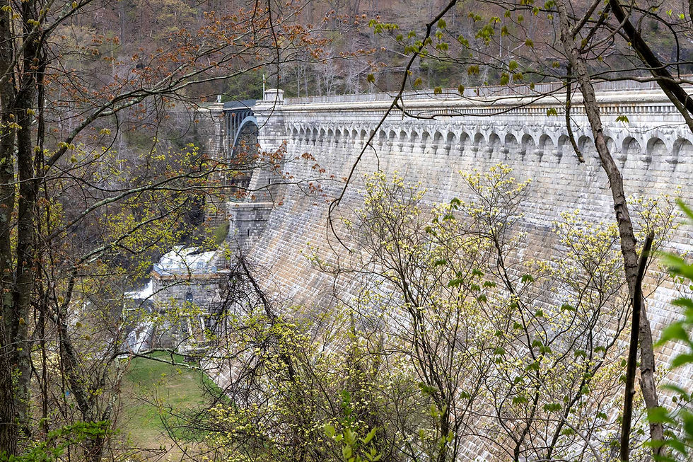
The rush of the river below built expectation for the terminus approach as we neared the dam. The exciting part of keeping the northern terminus the finale is not only the sensory experience of the Croton River, the cool air from the valley, and the sounds of whitewater, but the glimpses of the imposing New Croton Dam that peeked through the leaves until we were close enough to see it in full.
The New Croton Dam is truly mammoth in proportion. What makes it even more stunning is the masonry, the batter of the wall, and the terracing effect that merges with the cliffs of the river. The view from the top across the reservoir is serene and lovely, but the real drama of the scene is taking the short hike down to the base of the dam and experiencing the waterfall up close.


The Croton River is also a really popular fishing destination. I remembered all the fly fishers I saw on my last venture to the park, and this time around, I wanted to cast my own line. I didn’t catch anything but a snag, but it was a good rest and a reset after the hike to relax by the river and enjoy the Spring cool.

Our initial plan out was to hike back and take the Quaker Bridge to the Croton Gorge Trail, getting a chance to see the other side of the gorge and taking the shorter hike back down the Tuesldale Drive to the Croton-Harmon train station. Unfortunately, the Quaker Bridge was closed, so we double-backed on the OCA and used “The Crossing,” a bike and pedestrian path along the Rt. 9 bridge over the marsh to the Croton-Harmon station.
Along the way, we bumped into one of the hardware store workers who recognized us right away and stopped to say hello. While a small gesture, the moment caught me as a particularly lovely end to the hike.
The Old Croton Aqueduct Trail is a treat for anyone with a bent for history, especially those eager to get in the weeds of municipal and regional history. The trail itself has a lovely, local feel. The weekdays we were out hiking, there was a marked shift in energy and traffic in after-work hours, with folks coming out to walk, jog, bird, and just enjoy the path in every section we walked through. While a bit tricky to truly thru-hike logistically, unless you have the money to spend on hotels, the proximity to the Metro-North and New York City subway makes it easy enough to plan in chunks and get on and off.
A marker in Ossining recognizes the trail as one of "New York State Urban Cultural Parks" and while I couldn't find much information on this specific designation, I can't think of a much better descriptor. The natural and architectural beauty of the trail aside, the OCA connects hikers to communities across the lower Hudson Valley, and the experience from neighborhood to neighborhood and town to town makes the trail such a great urban hike.

-- Donnie "Babysteps" Welch
-- Photos by Jonathan "J-Dub" Welch (& a few by Donnie too!)
_______ Sources 1. https://parks.ny.gov/visit/state-parks/old-croton-aqueduct-state-historic 2. parkhttps://www.nyc.gov/site/dep/water/history-of-new-york-citys-drinking-water.page


Comments