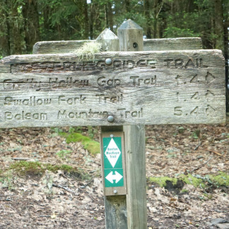
BMT-AT Loop: Smokies
- Brothers Welch
- Jul 19, 2021
- 18 min read
Day 1 Big Creek: Mile 0.0
We had been debating where exactly we wanted to start our Benton MacKaye Trail (BMT)- Appalachian Trail (AT) Loop hike. While it seems most hikers travel northbound, or NOBO, and the guide (and signage as we would come to find out) is predominantly oriented in that direction, it logistically made more sense for us to head southbound, or SOBO, and start off in the Great Smoky Mountains National Park or the Smokies.
The Smokies, like many National Parks, have a backcountry camping permit system which means we had to reserve specific campsites on specific dates. The reservations can be made online or over the phone and are really a pretty simple process, though it can feel overwhelming when added to the to-do list of a long hike.
AT hikers are able to obtain a “thru-hiker” permit allowing them to camp at any designated site they pass in the park, the caveat being that if it’s full and someone with a reservation shows up demanding a space they’re expected to move along. When I was making our reservation, the operator at the backcountry office mentioned that they recommended a Benton MacKaye pass similar to the AT one, but that the idea was shot down by their manager. I for one, think it would be a helpful thing, especially as folks seek out the BMT as an alternative start for their AT thru-hikes.
Our initial plan was to hike to the top of Mount Sterling and camp at the Mount Sterling Campsite, campsite 38, however J-Dub pointed out that this plan didn’t take into account how stormy the Smokies can be, especially in the summer, so we revised and spent the first night at Big Creek Campground, a campground for tenting only which you can drive right up. The spot has large tenting pads and lovely access to the eponymous Big Creek. The reservation cost $17.50 for a tent pad for one night, that fit both of our tents comfortably, and a picnic table.
Our parents helped us out by driving us up from the Charlotte area early Friday morning. It was really fun riding up with them and reminiscent of some of the road trips we’d take out to the American West when I was young. We got an early start to stay ahead of traffic in and around the park.
Our first stop was to drop off a food cache for ourselves at the bear box behind the Smokemont Campground ranger station. The BMT guide mentions that many thru-hikers use this as a resupply, and since we were planning seven days out in the Smokies it made sense for us to do the same. We planned to carry two(ish) days worth of food and pick up the other five(ish) at Smokemont. I say “ish” because our permit had us hitting Smokemont around midday, so we needed breakfast and lunch in our carry, but would be picking up dinner.
After dropping off the package at the Smokemont bear box we drove up New Found Gap Road, US 441, a scenic drive through the heart of the Smokies, stopping at a few pull offs along the way to enjoy the trip and do the touristy thing. While we could have backtracked and reached Big Creek via I-40, we thought it’d be fun to see the park and J-Dub did the driving so that our parents could sit back and do some sight-seeing.
New Found Gap Road let us out right into Gatlinburg, the tourist trap of the Smokies. It was a trip driving through it, and we all had to fight the temptation to rent dune-buggies, but we soon found ourselves on Tennessee 32, a windy mountain road that riders compare to the Tail of the Dragon. TN 32 lead us up a back way Big Creek and kept our folks within striking distance of I-40 for the trip back.
Dropped off around noon we had plenty of time to set up, get comfy, and eat some hummus and chips our parents left with us. Car camping at it's finest! With time to kill, we decided to hike up to Midnight Hole Falls, a popular day hike spot leadign to a lovely waterfall and swimming hole. It was pretty crowded so we just checked it out briefly and headed back.
The day hike left us thirsty so we drank much of what we brought, leaving enough water for the morning, but leaving us none to make coffee with. We could have grabbed water from the Creek, but it was a fairly large body of water, so wanted to be cautious of that. The campsite also had a wash sink, but seemingly no potable water as most folks mainly carried from their cars to their tents. I confirmed with our neighbors, a family out camping, that there, in fact, was no potable water and when they confirmed, they also offered us some for morning coffee. They were leaving early the next morning and insisted we take them up on it. This would prove to be the first of many incidents of Trail Magic along the BMT for us.


Day 2 Laurel Gap Shelter: Mile 11.9
Up early (and with coffee!) we set off up the steep ascent of Mt. Sterling. The mountain is the largest of the BMT, so we were prepped to tackle a monster. It ascends to a height of 5,842 feet over 6.2 miles of hiking.
What we weren’t as prepared for is how the humidity would absolutely wreck us. We were swimming in our clothes within the first couple miles of the morning. The ascent is switchbacked, a favorite technique of southeast trail maintainers. A switchback means that rather than a direct ascent, the trail winds slowly around the mountains. Imagine doing a stair master in a gym without air conditioning on the lowest possible setting, but one that’s still high enough to feel it, for about three hours and you’ll come close to replicating our experience. We knew starting in the Smokies would be logistically easier though physically tougher, but PHEW Mt. Sterling was a beast.
Once up Mt. Sterling we paused to re-fill water and snack by the tower and campsite. The water was a steep down, but a nice piped, spring source that was flowing well for us in early July. The summit was all clouded in, so there were no views off the tower or around us. We pressed on and headed down towards our stop for the night. Laurel Gap Shelter.
The trail down was a fairly wide trail shared with horses and pack animals that narrows out at certain points. It wasn’t too tough of terrain, though working toward an 11.9 mile first day, felt a bit tough after that climb up Mt. Sterling.
Laurel Gap is one of the few shelters on this trail and one of the few shelters outside of the AT in the Smokies. COVID restrictions allowed for tenting outside shelter, though typically reservation holders are expected to stay in the shelter.
We opted to tent as we usually get better sleep in tents without any bug or mouse interference and found a spot nearby to pitch. The water was, once again, a steep down to a pipe fed by a stream which was clear and strong for us in early July, and incredibly welcome after a tough day in high-humidity. We made a few trips down. J-Dub and I also brought some hammocks to lounge in and cool down our body heat and I was able to set up my hammock quite easily around the shelter as well.


Day 3 Enloe Creek: Mile 21.8
Walking up early after a stormy night we made quick work of the descent to Straight Fork Road.
The ascent up to the Hyatt Ridge Trail really beat us up, in part because our bodies were still recovering from that massive first day climb. However, this is climb also goes about 2000 feet over three miles, so it’s certainly no joke!
We carried ourselves up and down to the lovely Enloe Creek campsite. It was a fairly small site, room for four or five tents max and not much in way of hammocks, but it’s right beside the large and rolling Enloe Creek.
We got in fairly early and rested and watered up again deciding that our current backcountry permit itinerary might be difficult to maintain in the humidity we made plans to change it and Smokemont and perhaps even stay there if the campground had room. Given that it was July in the Smokies we weren’t sure we’d be able to secure a tent pad, but the Smokies backcountry reservations allow for a change so we were at least confident about that.


Day 4 Smokemont Campground: Mile 30.6
Enloe Creek had a burshy, steep climb out of it’s gorge. There was also a point at which we were supposed to ford, but the water level was fairly low so we were able to rock hop our way across.
Reaching the junction with the Hughes Ridge Trail, it was all fairly smooth sailing down into Smokemont itself. The BMT veers around the campground, but hikers can reach it via the Bradley Fork Trail and have those miles still counted toward a thru-hike which is what J-Dub and I opted for. We entered Smokemont in the back by the RV parking and even just two and a half days in, the lure of the glamp was strong. With festival style rain tarps and grills, the grass definitely looked pretty green.
We made short work of the campground to the bear box and got our resupply. J-dub asked the ranger in the station if there were any walk-in reservations left and she informed him that indeed there was one, and that she’d be willing to hold it for us for a bit while we made up our minds.
With a stop secured-ish, we next decided how we would alter our backcountry permit. The reason we chose Smokemont as our location is because the ranger station has a landline attached to it with direct access to the backcountry office.
We sat down with the guide and picked out our spots. We wanted to break up some of the harder days a bit while also ensuring we camped in gaps, or the low points between mountains, to avoid the brunt of any passing night time storms which frequent the park over the summer.
The phone was convenient, however the reception wasn’t, exactly, ideal. The first conversation between myself and the backcountry office went:
“Hello”
“Hello! Are you calling for Smokemont?”
“Uhm, yeah?”
“Ah, I can always tell because of the phone.”
And ended shortly there with my having to call back because of static.
The second call got through however and J-Dub and I were able to change our plans to camp a bit more safely in the summer and give our trail legs time to kick in. With our plans reset, we paid the $25.00 fee for the tent pad at Smokemont and set up our spot.
Actually, first, we had to clean it up.
A previous tenant had dumped a whole thing of diced onion on their way out! I won’t get too high on my soap box here, but trashing a National Park Campsite is disrespectful, dangerous, and disgusting. We borrowed a shovel from the ranger station and set to work getting rid of the food litter.
After that we pitched our tents, hung our hammocks, and proceeded to lounge. We had hiked about 8.8 miles to get into Smokemont. Since we’re early birds it felt like we were just passing the day away, but actually the rest was well deserved.
The guide mentioned a camp store about 0.5 miles away from Smokemont. In reading, I had read “ice cream” much like a desert wanderer having a mirage. In fact the guide said, and the store sells, "ice" for campers along with firewood. However they also sell some single dose medicines and hygiene products which could be useful for thru-hikers resupplying. The store is part of the Smokemont Stables and the “visitor waiting” area has a vending machine with candy, jerky, and crackers and a soda machine which dispenses change in the form of golden dollars. The vending machine is older and a bit temperamental, only accepting dollar bills, however the staff at the camp store were kind enough to break bills and exchange the golden dollars with us.
Back at the campground we took stock of our resupply as our neighbors Tom and Carolyn pulled in. They had a really cool, classy camper van set up and used their tent pad as shelter for their bikes and equipment. They were an older couple from Long Island on a summer adventure, they had recently been to Shenandoah before coming down to the Smokies. Tom showed us some Elk and Bear photos they managed to get on their hikes and Carolyn asked us about thru-hiking as she’s always been interested in an AT hike.
We spent some time chatting and they passed on some snacks which, we really needed having spent most of our time meticulously planning meals we underestimated how snacky the humidity and heat would make us feel. Later that night, Tom asked us if we’d like some pasta which, of course, we absolutely did. He brought over two heaping bowls of penne joking, “I used to be a waiter in New York, if you’d like some coffee or dessert just let me know.”
The pasta was delicious! We didn’t see their full set up, but whatever kitchen set-up they have in that van, they have it going on!
They wouldn’t accept any money for all their kindness, so J-Dub traded some 2012 BMT guides he was carrying. While the route has changed, J-Dub was carrying them because of the bits of history and local lore they had. Tom took them, and we hope it inspires them to get out on the trail a bit! For a couple interested in thru-hiking they certainly became trail angels for us.


Day 5 Pole Road Campsite: Mile 43.4
Bellies full of penne, we started the ascent up Newtown Bald, a roughly 3000 foot climb from Smokemont to the Mingus Creek Trail intersection over the course of 4.9 miles. While not as intense as our opening day Mt. Sterling ascent, it was definitely still a doozy.
We took a short water and snack break at the Newton Bald campground, a spot on our original itinerary, which was a bit fogged in for us, but on a clear day I can imagine has quite a nice view. here the trail runs along the Mountain to Sea Trail, a 1175 mile thru-hike running across North Carolina from Clingman's Dome in the Smokies to Jockey's Ridge State Park in the OuterBanks.
Stopping to rest at the Sunkota Ridge junction we met a trio out hiking the Mountain to Sea Trail. Two of the three were finishing up the last 19 miles of their thru-hike after being unable to ford Deep Creek in the spring. The third was, "just along for this part!" We talked with them for a bit and learned a good deal about the trail, including a trail angel system who make the trail both more accessible and affordable by helping hikers out and providing spots to camp or sleep so that they don't have to pay for hotels/motels along the way.
We followed the trail down, with a few sharp ups along the way, to campsite 55 Pole Road Campsite beside Deep Creek. The site was pretty nice, though a closely shared horse space. There were a few flat spots for good tenting and some trees for hammock hangs.
We had a ranger leading, what we believe were, junior rangers on a camping expedition join us toward the late afternoon. She seemed to have enough on her hands with the youth expedition and, while friendly, left us alone, camping on the other side of the site.


Day 6 Mill Creek Campsite: Mile 51.9
Another steep, humid up from our campsite to the Noland Divide Trail intersection. The Smokies were unrelenting for a start, but we were beginning to feel our trail legs today. This one went up 1890 feet over three miles and even in the morning was a tough climb.
Once at the top, we headed down and soon started our fords.
Because it's summer the water levels were pretty low and the only fords that were still true fords were the two Noland Creek crossings, one a bit higher than ankle deep, the other at shin, almost knee, level. The trail follows Noland Creek and crosses over some log footbridges for the next few miles into Mill Creek Campsite #64
We got in as a family came horseback riding down. While we had seen horseshoe prints and horse poop along a lot of trail in the Smokies we had yet to see any riders or pack trains so this was our first siting! They were from Bryson City and tipped us to a nice swimming hole by the bridge at the campsite. They also let us know we were only four miles from the "road to nowhere" which would be a big destination for us tomorrow.
We set up a tarp to wait out an afternoon storm under once the riders headed back to the road. This was a helpful little trick for us and something we plan to do throughout the rest of the trail. Since there are few formal shelters on the BMT we brought tarps to be able to make our own shelters for the pop-up thunderstorms that frequent southern afternoons.
I went to explore the campground a bit and snap a photo of the backcountry stables since I realized we hadn't gotten a shot of one yet. On my way back, I came across a big timber rattler sunning itself and digesting, or I assume digesting, given the large bump it.
I gave it a wide berth and didn't think much of it since it was on the far end of the site.
The rest of the day we spent hanging out in our hammocks, recovering, hydrating and doing some general foot care.
Come dinner time we moved down to one of the lower campsite picnic tables to eat away from our sleeping spot. It was late enough that we figured no one was coming and it was the spot right by trail so pretty undesirable anyway. I stepped away to pee and when I came back I heard a hearty rattle that stopped me in tracks. My old friend the timber rattler was on the other side of the fire pit sitting logs, only a few feet from me, but even closer to J-Dub who wouldn't have been able to see him over the logs.
We carefully moved our operation to another picnic table and watched our new friend with caution and curiosity. It was a rare opportunity: observing a wild rattler and it's behaviors, but we also didn't know the radius of the creature and if it moved from the stables down to here, we didn’t want our campsite to be next.
Eventually, it curled up under a log at the fire pit and seemed like it was settling for the night. Or, at least, that was the sense we got. We lingered for a bit in case anyone did straggle in late because the snake was curled under the perfect sitting log after a late afternoon/evening push. The kind you would eye all the way in as soon as you saw it.
As night fell we got set for camp and fell, surprisingly, pretty quickly to sleep, though we listened closely to slight rattle of summer bugs' hums.


Day 7 Chambers Creek: Mile 65.90
Our old friend the snake was still in the same spot. J-Dub and I like to get up and out early to get as much hiking done before the heat and height of the afternoon, so the snake was still in a sleepy curl.
Walking up a gravel road a bit we eventually came up to the Lakeshore Drive. A short road walk brought us to the unceremonious end of the road where there was a trailhead parking lot and signs for the tunnel bypass trail. We kept on and as the paved road switched to dirt we found ourselves on the Road to Nowhere and the Tunnel to Nowhere, part of a failed eminent domain project to reconnect a highway which was flooded with the creation of Lake Fontana.
After the tunnel we were on the Lakeshore Trail, our last of the Smokies. The trailed rolled steeply up and down, a bit more up it seemed, as it brought us to Lake Fontana. At campsite 74 we caught our first little view of the lake down a side trail.
At the campsite there were National Parks Trail maintainers eating breakfast and as we pushed along to Chambers Creek we saw and benefited from the results of their work, especially some rhododendron cutting over narrow passages of the trail.
The campsite is off a short side trail with a creek for water and plenty of tent and hammock sites. We made a little fire to pass the night at camp while thinking and planning ahead to tomorrow and then Fontana


Day 7 North Shore Campsite: mile 76.8
This part of the Lakeshore Trail brought us closer to the actual lake than the other section had. There were some beautiful coves and vistas along our hike.There was also a good amount of brush and J-Dub wound up with a nasty yellow jacket sting on his achilles. We must have accidentally stirred up a ground hive so we got a bit of trail running in for the day too.
Campsite 77 had the best lake access of any of the campsites we saw. A beautiful little cove you could walk right out into. We stopped and ate an early lunch there looking out at the lake. There's also a single, long picnic table situated in a nice spot beside the creek which is the site's water source. The actual camp site was in a bit so we didn't see the spots, but if the surroundings are any indication, they're probably pretty good!
Moving on we climbed the short, sweaty up and downs to North Cove, a nice site with two camping areas, one close to the lake the other a bit more inland. The lake access was another cove, a bit more ideal for boating or fishing than swimming, but a nice view all the same.


Day 8 Fontana Village & Resort Campground: Mile 91.7
Tried to get up early, but a problem with my headlamp meant we had to wait out the sunrise a bit. It seems the metal bits on the end that hold the batteries in place have worn down, nothing much to do.
Still got a slightly early start since we were all packed up. Normally we wake up at 5:00am and aim to get on trail around 6:30, 7:00 after breakfast. Today we were able to hit the trail right at 5:00am. I used the flashlight function on J-Dub’s portable charger to light my way a bit until the sun soon peaked through.
This part of the Lakeshore trail was, terrain wise, like much of the trail before it. Steep ups and downs, though I did notice it widened a bit here as we got closer to Fontana.
The trail passed through the site of Proctor, a former logging town and one of many former towns that occupied the land of the park. In the park’s own words:
More than 1,200 land-owners had to leave their land once the park was established. They left behind many farm buildings, mills, schools, and churches. Over 70 of these structures have since been preserved so that Great Smoky Mountains National Park now contains the largest collection of historic log buildings in the East.
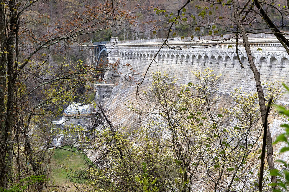
As the heat encroached we continued our march into Fontana. This would be our biggest day yet, pushing our trail legs a bit before taking a zero day. By the time we got to the road walk portion and the dam itself the sun was bearing down and we were pulled along by the possibility of snacks at the Fontana Dam Visitor center however, we were disappointed (to say the least) to find the store closed!
We sat on our bear vans and weighed our options. We knew there was a shuttle to the village that would pick us up at the Fontana Marina, but that would be another 1.1 miles of road walking which, at 2:45pm on a sunny day, did not sound fun.
Just as we were confronting the reality of the road walk before us, an a hiker came around the corner asking, “Are you guys waiting for the shuttle?”
“The shuttle?” J-Dub asked.
“Yeah the shuttle to Fontana?”
“We are now, yeah we’re waiting for the shuttle!”
Come to find out the village shuttle runs up to the visitor center on it’s route now as well. The hiker was John, out for a section of the Appalachian Trail from Springer to Clingman’s Dome with his friend Grant. We were buoyed by this new information and for $6 ($3 each) we found ourselves zooming down the mountain roads in a resort van full of hikers.
The shuttle driver was a young woman from nearby Robbinsville named Lydia. She had a wealth of information both about the resort and the local area and went out of her way to answer all the hikers' questions and pick up a hiker who had been running to catch up to the van!
The Fontana Village Resort itself was filled up with a car club meeting. There were about a hundred Shelby GT drivers up to ride the Dragon! This twisty mountain road is proving to be a through line for this adventure.
We opted to stay down at the campgrounds 1.5 miles away from the Resort itself, but accessible via the shuttle which leaves the main lodge for the full loop to the visitor center at: 9:00am, 11:30am, 3:00pm, 4:30pm. As note, we had to ask Lydia to bring us down. The shuttle doesn’t typically add the campsite unless it’s upon request.
The front desk would also call up the maintenance staff to give us a ride down in their truck if we needed to get to the campsite at an off hour from the shuttle.
The campsite itself was in a really unique location, right on the river look up at the towering Fontana Dam. It’s an ideal spot for on RV or elaborate car camp set up, but could definitely do with some tent pads for the tent campers the resort is aiming to accommodate. The sites are mainly on large field which, in the heavy rains of the Smokies, got flooded in a lot of spots. We managed to find a dry patch and set-up alright, deciding that the access to shuttles and the resort amenities made it still worth the $35.00 camping fee.


Day 8 Fontana Village & Resort Campground: Mile 91.7 (Zero Day)
We woke up and caught a ride up to the resort for the Buffet breakfast!
Content and coffeed up we began our chores for the day: Charging our tech, doing laundry, showering, a small snack resupply and new headlamp from the campstore, writing this post and, of course, riding on the lazy river.
John and Grant were around on a zero as well, "zero" meaning doing zero miles or taking a rest day, and doing much the same, so we passed some time with them throughout the day.
Relaxed and recovered we caught a ride down at night with an Appalachian Thru-hiker Class of 97’ and now Trail Maintainer Ox. He has been maintaining for over 20 years!
He currently works with the Smoky Mountain Hiking Club out of Knoxville, Tennessee and maintains the AT section from Fontana to the Nantahala Outdoor Center. He was staying at the Fontana “Hilton” Shelter after finishing some trail work around the area, recently installing some 53 new stone steps up the northside of Cheoah Bald.


Day 9 Fontana onward!
We passed one last rainy night at the campground and caught a ride back up with Ox who came through to see if we might need a lift, which we did!
The Fontana Post Office is only open Mon-Fri 11:45am to 3:45am so it’s fairly narrow window. Fontana was a pleasant stay, but if you’re looking to mosey through the area I’d definitely seek a drop elsewhere.
With our food replenished, we’re headed off into The Wilds!


need some food sent ahead to you? Post offices will hold on to packages for 30 days in General Delivery! What towns will you be in, and what would you like sent?